BRITAIN BENEATH · GUIDE · 8 OCTOBER 2026
Glenesk Bridge: A Footpath in the Photo, a Railway Today
The 2008 photograph shows Glenesk Bridge as a walking and cycling route. Trains returned in 2015. The old picture must not be used as a guide to access today.
Based on published records and visitor information. We have not visited these places.
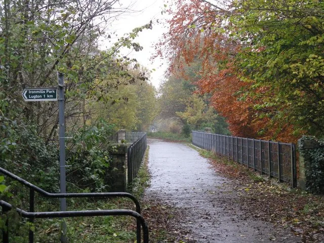
Glenesk Bridge on 6 November 2008, when walkers and cyclists used it. Trains later returned. This is not a walking route open today.
Bridge over the River North Esk by M J Richardson · CC BY-SA 2.0. Converted to WebP; thumbnail resized, no cropping. Both derivatives remain available under CC BY-SA 2.0.

A path in the old photo
In M J Richardson’s photograph of Glenesk Bridge, railings and autumn trees surround a path without tracks. Walkers and cyclists used the crossing when he took the picture on 6 November 2008. That route is no longer open to them: trains returned in 2015.
The bridge began as part of the Edinburgh and Dalkeith Railway. James Jardine’s stone arch crossed the River North Esk in 1829–31. Later closure and repairs made it a public path for a time.
The return to railway use is not the only change in its accepted history. Some older accounts dated the bridge to 1847. Research led Historic Environment Scotland to adopt the earlier date and raise its protection to Category A.
- Glenesk Railway Viaduct, LB1445 ↗ · reviewed 2026-10-07
- Bridge over the River North Esk, photograph 1035626 ↗ · reviewed 2026-10-07
- Edinburgh & Dalkeith Railway: Glenesk Bridge, Dalkeith — the case for an 1829–31 date of origin ↗ · reviewed 2026-10-07
- Edinburgh and Dalkeith Railway, Glenesk Bridge, Bridge No. 12 ↗ · reviewed 2026-10-07
- Edinburgh and Lothians Greenspace Trust v Network Rail Infrastructure Limited ↗ · reviewed 2026-10-07
- Borders Railway Year 1 Evaluation: Background ↗ · reviewed 2026-10-07
Research changed the date
Some older accounts dated the bridge to 1847. They suggested it replaced a wooden one. Research published by Roland Paxton in 1993 challenged that story.
He argued that the stonework below track level came from the original 1829–31 bridge. His evidence included its shape and the width needed by the early railway. Historic Environment Scotland adopted the earlier date and named Jardine. It raised the bridge’s heritage status from Category B to A in January 1994.
- Edinburgh & Dalkeith Railway: Glenesk Bridge, Dalkeith — the case for an 1829–31 date of origin ↗ · reviewed 2026-10-07
- Edinburgh and Dalkeith Railway, Glenesk Bridge, Bridge No. 12 ↗ · reviewed 2026-10-07
- Glenesk Railway Viaduct, LB1445 ↗ · reviewed 2026-10-07
The years when people walked across
The through railway closed in 1969. By 1990, the bridge needed repairs. A later tribunal decision records Midlothian Council asking Edinburgh Green Belt Trust to own and restore it.
The trust raised money. After repairs, walkers and cyclists used the crossing. The 2008 photo shows that phase.
- Edinburgh and Lothians Greenspace Trust v Network Rail Infrastructure Limited ↗ · reviewed 2026-10-07
- Bridge over the River North Esk, photograph 1035626 ↗ · reviewed 2026-10-07
The trains returned
In 2008, the bridge was bought for the Waverley Railway project. The tribunal account traces its transfer into Network Rail ownership. The Borders Railway opened to passengers on 6 September 2015.
Trains again linked Edinburgh and Tweedbank. The former footpath became part of the railway.
Some old heritage text still describes the trackless years. That is the phase in the photograph, not today’s railway. The return of trains ended the walking crossing rather than placing trains beside an unchanged public path.
- Edinburgh and Lothians Greenspace Trust v Network Rail Infrastructure Limited ↗ · reviewed 2026-10-07
- Borders Railway Year 1 Evaluation: Background ↗ · reviewed 2026-10-07
- Glenesk Railway Viaduct, LB1445 ↗ · reviewed 2026-10-07
A railway crossing today
For a train journey, use ScotRail’s Edinburgh–Tweedbank planner and check services for your day. The passenger line uses the bridge, but a train ticket does not promise a clear view of its stone arch. We have not checked seats or views.
The deck is not open for public walking or cycling. Do not copy the route in the 2008 photo or enter the tracks. For an outside view, stay on lawful public paths and follow barriers.
We have not confirmed a current viewpoint, step-free approach or safe riverside route, so we give no walking directions. The 2008 photo shows a former footpath. Do not use it as evidence of a walking route today.
- Trains from Edinburgh (Waverley) to Tweedbank ↗ · reviewed 2026-10-07
- Borders Railway Year 1 Evaluation: Background ↗ · reviewed 2026-10-07
- Bridge over the River North Esk, photograph 1035626 ↗ · reviewed 2026-10-07
Sources and further reading
Sources were checked on 7 October 2026. Historic Environment Scotland records identify and date the bridge. Direct page access failed for Paxton’s research introduction and the 2016 tribunal decision. We read their text through search results. Transport Scotland confirms the 2015 reopening. ScotRail gives journey details. We have not visited, contacted staff or confirmed a public viewpoint. The 2008 photo shows an earlier use, not a path open today. The 1 place records below give more information.
You can follow the links to read the original sources. Sources and permissions.