BRITAIN BENEATH · GUIDE · 8 OCTOBER 2026
Stockport Viaduct: How Workers Widened the Giant Brick Crossing
Stockport’s railway bridge opened in 1840 with twenty-eight arches. Nearly fifty years later, workers widened its west side to make room for more tracks.
Based on published records and visitor information. We have not visited these places.
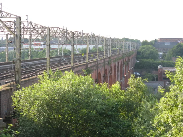
Stockport’s working railway bridge in June 2010. The track above is not a walking route.
Stockport Viaduct by Peter Whatley · CC BY-SA 2.0. Wikimedia rendition converted to WebP and resized where needed; no cropping or retouching. Photographic derivatives remain under the stated licence.

Keeping the railway high
Workers widened Stockport Viaduct in 1888–1889, adding room for more tracks along its west side. The first bridge had opened in 1840. Its later enlargement helped the railway carry more traffic without abandoning the valley crossing.
Engineer G. W. Buck designed the original structure for the Manchester and Birmingham Railway. Its twenty-eight arches carried the tracks across both the river and the lower ground around it.
Historic England records a length of more than 540 metres and a height nearly 34 metres above the river. Trains still cross it. Public streets offer views of the brickwork below; the railway deck is not a walking route.
- Historic England — Stockport Railway Viaduct ↗ · reviewed 2026-09-13
Widening the bridge for more tracks
The twenty-eight arches form a long row across the valley. Each spans a gap between supports. From ground level, you can see the structure holding the tracks high above the lower ground.
Historic England dates the widening to 1888–1889. Workers added space along the west side of the bridge for more tracks. The crossing now includes both its original construction and that later work.
Historic England estimates that the viaduct contains eleven million bricks. It also records twenty-eight arches. The size of the original crossing and the later widening explain why the bridge remains such a large feature of the town.
Its Grade II* listing recognises its historic value. That protection sits alongside its railway use. It does not turn the deck into a public walkway or remove the need for maintenance.
- Historic England — Stockport Railway Viaduct ↗ · reviewed 2026-09-13
Views from below
Public streets give views of the bridge. In June 2024, Stockport Council announced a walking link between Viaduct Park, the transport interchange and the River Mersey frontage. Check current council advice and follow signs or diversions.
A riverside path does not open the railway above. Choose a safe place to stop when looking up or taking photos. Keep away from traffic. Do not enter fenced land, tracks or maintenance areas.
We have not inspected the current paths, river conditions or step-free access. Check those details if they affect your visit. An old photo cannot settle them.
From below, you can see the arches that support today’s train journeys. The widened structure records the work done when the railway needed more tracks, nearly fifty years after the first opening.
- Stockport riverfront ramp opens ↗ · reviewed 2026-10-07
- Historic England — Stockport Railway Viaduct ↗ · reviewed 2026-09-13
Sources and further reading
Based on the linked official heritage records and visitor pages. We have not visited or confirmed access directly. Older descriptions and photos may not reflect today’s condition. Check current official visitor advice before travelling. The 1 place records below give more information.
- Stockport Railway Viaduct — 1356861
You can follow the links to read the original sources. Sources and permissions.